As we close out 2025, we're reflecting on a year of transformation for Lens. The remote monitoring landscape has evolved rapidly, and we've worked alongside our incredible customers to build a platform that's faster, smarter, and more capable than ever before. We're thrilled to share these highlights from 2025 and give you a glimpse of what's ahead!
Lens users were busy this year, conserving important places, monitoring carbon projects, managing critical infrastructure, and protecting biodiversity around the globe. With near-universal imagery coverage, we’re continuing to realize our commitment of making high-resolution data accessible wherever you're working.
.png)
We expanded our global presence to 73 countries across 6 continents.
135.8 million acres monitored – an area larger than Spain!
1,467 users actively monitoring properties in Lens
3.6 million acres of commercial imagery ordered – fueling deeper insights across portfolios
25,680 notes created – tracking observations and changes across properties
40+ public datasets, 15 commercial, and 15 vector overlays - the Lens library is more comprehensive than ever!
Lens is more powerful than ever before! We made major strides towards faster, smarter, and more scalable remote monitoring. From portfolio-level intelligence to automated monitoring and more precise change detection, Lens has evolved into a platform that handles greater complexity, supports more industries, and delivers more value to users.
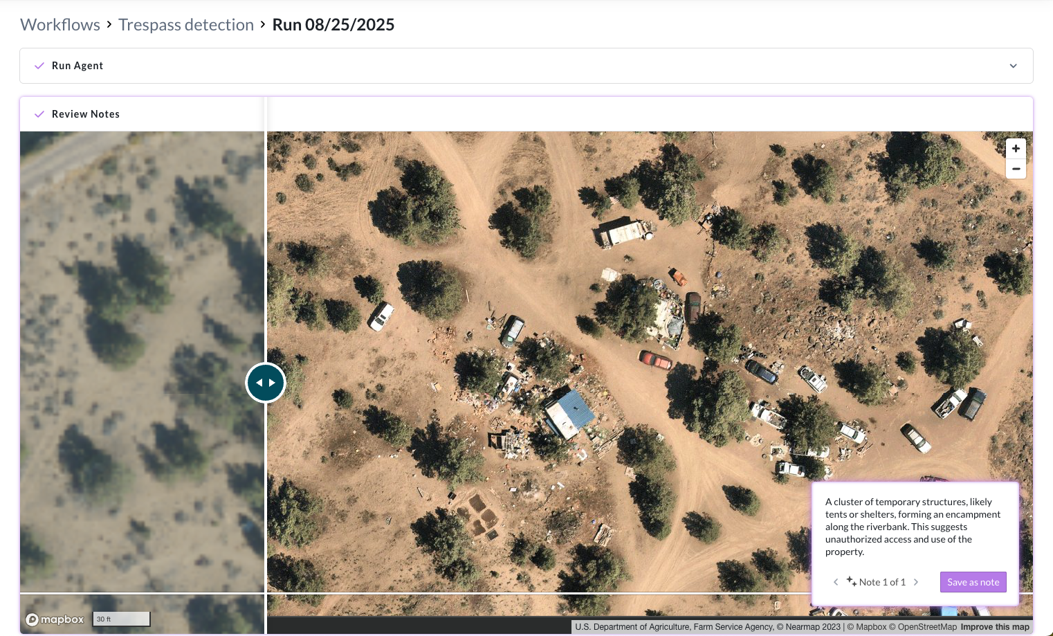
In 2025, we laid the foundation for fully automated monitoring workflows with the Lens agent. Starting with trespass detection and streamlined review flows, Lens is building a first of its kind AI-powered land monitoring agent to highlight the most important changes across a portfolio and guide users through them efficiently. This represents a major step toward scalable, efficient monitoring with automation that keeps humans in the loop. Imagine being able to spot critical land changes across hundreds or even thousands of sites automatically, with confidence, and without the inefficiency of manual tracking. We can’t wait to show you what’s next!
Watch our latest webinar on proactive trespass detection with AI →
This year we were proud to launch portfolio-level monitoring through customizable dashboards in Lens. Dashboards bring multi-property charts, filtering, and sharing capabilities that support organization-level insights. For the first time, teams can understand trends and patterns across their entire portfolio at a glance, making strategic decisions with confidence.
Lens Lookout, which enables configurable change detection alerts, received its biggest upgrade yet—making alerts more precise, meaningful, and aligned with real-world monitoring needs. Now you're alerted to the right changes, in the right places, at the right time. Updates include new spatial rules, new temporal rules, a clearer setup flow with time-series preview, and ongoing improvements to unseasonal vegetation drop alerts.
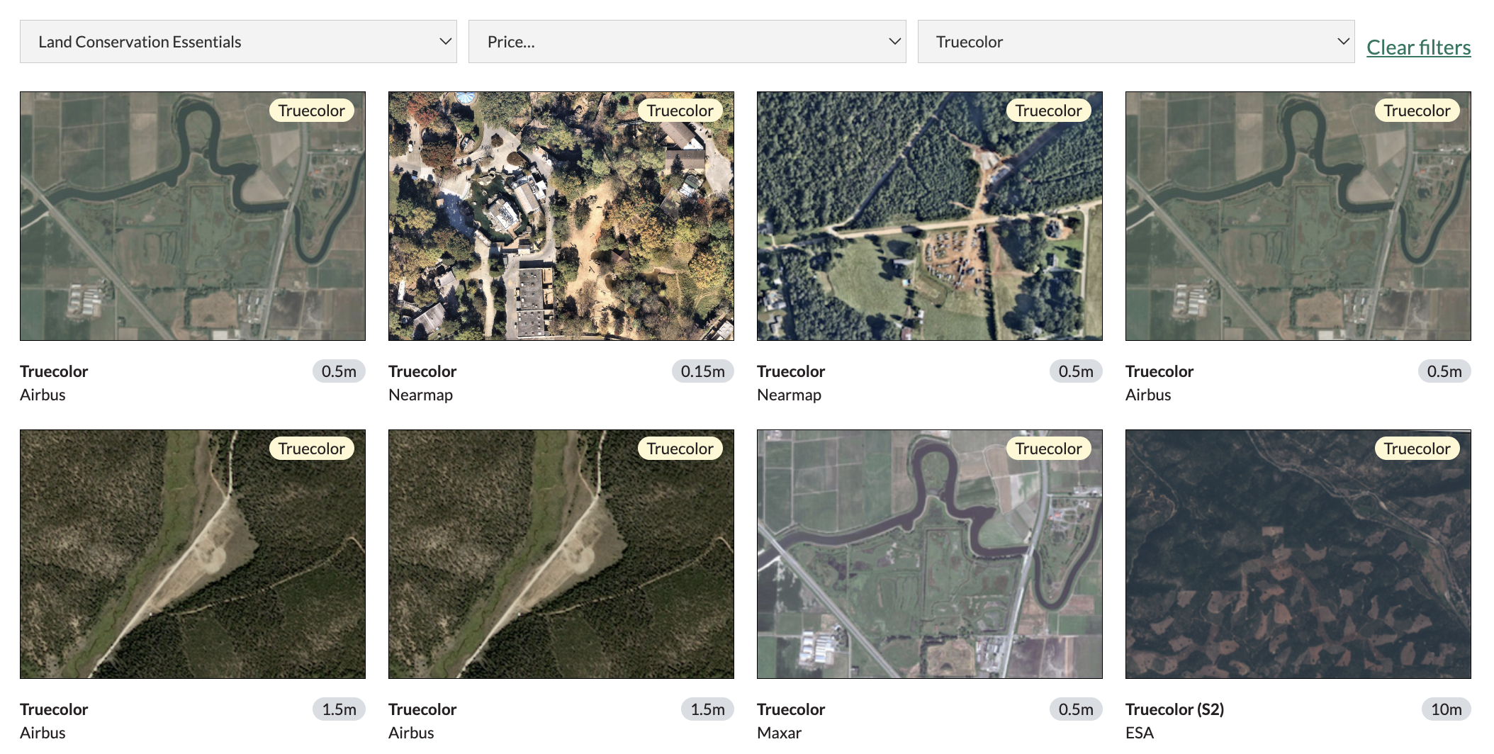
The Lens Library has never been more comprehensive, offering over 40 public datasets, 15 leading commercial datasets, and 15 vector overlays.
Highlights from some of the new datasets we added this year include:
American Forest Foundation (AFF): We’re proud to continue to power American Forest Foundation’s Family Forest Carbon Program. “In 2025, Upstream Tech's Lens tool and staff continued to be a critical tool for the Family Forest Carbon Program's learning and implementation of Natural Climate Solutions (NCS). Their data, people, and platforms helped us smoothly identify changes across hundreds of small landowner properties implementing NCS so that we could support our landowners and accurately account for forest carbon changes. Additionally, Upstream Tech staff supported the generation of our first dynamic baseline datasets for our reforestation program, iteratively adapting and finding what worked and met the CCP-approved methodology VM0047. We appreciate the Upstream Tech team so much and look forward to more exciting and meaningful collaboration in 2026!” - Lynn Riley, Lead Scientist at American Forest Foundation
Sonoma County Ag + Open Space: “Lens provides easy access to high-quality imagery with excellent technical support. It’s been an invaluable tool for our team at the Sonoma County Agricultural Preservation and Open Space District as we monitor and steward lands across our county. Having reliable satellite data at our fingertips helps us efficiently stay informed about conditions on the land and make timely, critical decisions to continue protecting the open spaces our community has entrusted us to protect.” - Jacob Newell, Stewardship Supervisor
The Trustees of Reservations: “Lens has really been a total game-changer addition to The Trustees’ CR Stewardship toolbox. It gives our team the ability to remotely monitor hundreds of properties across Massachusetts with up‑to‑date, high-quality imagery, saving valuable time in the field. With Lens, we can more efficiently uphold our commitment to protecting and caring for the state’s most scenic, historic, and ecologically significant places.” - Sally Naser, Conservation Restriction Stewardship Director
Broadwater Innovations: “Lens has been a game-changer for our team — it’s easy to use, delivers high-quality imagery, and is backed by wonderful customer service. As we work to conserve and protect land and biodiversity across Virginia and beyond, having a reliable, intuitive tool like Lens helps us track progress, document success, and make confident, data-driven decisions for the landscapes we steward.” Ben Garden, Stewardship Manager

Northwoods Land Trust: This year, we sat down with Troy Walters, Outreach & Monitoring Coordinator at Northwoods Land Trust, to explore how they leverage Lens to save time, resources and strengthen land owner relationships. Troy let us know that using Lens alongside site visits “saves money and time, but more importantly allows me to see the whole property. If you look at what percentage you can actually monitor on the ground, it’s pretty minimal. Lens allows me to focus my efforts where I can actually be helpful.” Read the customer spotlight.
The Nature Trust of New Brunswick: We hosted a session this year in partnership with Ontario Land Trust Alliance (OLTA) and Lens customer, The Nature Trust of New Brunswick, to discuss how Canadian conservation organizations can level up their stewardship and planning work with remote monitoring tools. Watch the on-demand webinar.
As remote sensing technology and applications evolve, we believe in the importance of knowledge sharing and collaboration. That’s why we continue to package up our learnings and insights into resources for our community.
.png)
Geospatial education: Whether it’s how to leverage NDVI, understanding satellite imagery resolution, or making sense of uncertainty in carbon datasets, our team of experts shed light on a variety of topics this year.
Remote monitoring for conservation: Learn how remote monitoring elevates wildlife conservation work or navigating the nuances of biodiversity monitoring
Key case studies - We recorded some of our favorite monitoring use cases this year, highlighting real-world examples where Lens is leveling up monitoring.
Explore all Lens case studies →
Looking ahead, we're doubling down on what makes Lens powerful: automation, intelligence, and accessibility. You can expect even more datasets added to the Lens library, an expanded range of commercial imagery offerings, and continued enhancements to features like Lens Lookout and Lens Agent to make passive monitoring even more efficient.
Most importantly, we're looking forward to continuing our work alongside the incredible organizations using Lens to protect forests, manage infrastructure, monitor carbon projects, and conserve biodiversity around the world. From the entire Lens team, thank you for your partnership and support—here’s to 2026!
To keep up with the latest from the Lens team, be sure to subscribe to the Lens Newsletter.
.png)