.png)
Many incorrectly think of hurricanes only as coastal events. But recent major inland storms like Hurricane Helene highlight why this misunderstanding can hinder preparedness in an extreme event that is already both challenging to predict and to respond to. They also underscore that forecast models can be better designed to handle the associated uncertainty. These challenges aren't new or unique to Helene. Storms causing intense flooding far away from coastlines have been recorded in the U.S. as far back as 1955 when Hurricane Diane became the first Atlantic hurricane to cause more than $1 billion in damage.
Inland damage from hurricane rainfall has devastating consequences. Between 2013 and 2023, about 55% of hurricane deaths were directly caused by rainfall, not wind or storm surge. Yet misconceptions and inconsistencies about the importance of understanding precipitation still leads to issues for emergency management and communication. Addressing this becomes even more urgent as climate shifts are causing more frequent and more intense storms. The good news is that forecasting technology is increasingly effective at predicting extreme events, providing new possibilities to address major gaps in disaster preparedness and response.
The good news is that forecasting technology is increasingly effective at predicting extreme events, providing new possibilities to address major gaps in disaster preparedness and response.
While hurricanes are categorized by wind speed, these categorizations become less meaningful as they move inland. When anticipating inland flooding—where flooding of rivers, creeks, and streams doesn’t occur near the coast—precipitation volume is a more urgent metric. This creates a concerning public misunderstanding about how hurricane categories relate to inland flood dangers.
Hurricane Helene exemplifies this disconnect. Helene dumped rain inland at various stages of its hurricane classification on the Saffir-Simpson Hurricane Wind Scale (SSHWS). While its wind speeds changed and hurricane classification changed, the massive volume of water it transported inland was a result of a separate meteorological process, creating severe flooding conditions across multiple states far from the coast.
Helene is a recent example but not the only one. According to a new research paper, during hurricanes Katrina (2005) and Florence (2018) most of the damage and deaths were caused by storm surge, rainfall, and flooding. The authors propose replacing the SSHWS with the Tropical Cyclone Severity Scale, which incorporates storm surge and rainfall in addition to wind.
Hurricane prediction models and public attention typically focus on storm surge and coastal impacts, underestimating inland flood risks and leaving these areas inadequately prepared. More accurate and reliable flow forecasts are essential to provide a clearer picture of the flood threat to communities far from the coast, regardless of its hurricane category.
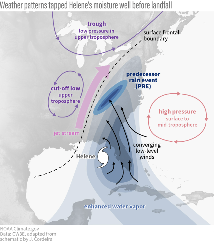
Regardless of where the center of the hurricane is, heavy rainfall can happen far from the eyewall. In these outer areas, the storm can interact with diverse terrain and other weather systems, which can significantly increase both the amount of rainfall and its impact.
Hurricane Helene offers a clear example of several meteorological factors compounding to create difficult-to-forecast flash flooding.
With each hurricane component comes an additional layer of uncertainty. This multi-layered uncertainty propagates through forecasts, making runoff predictions for inland hurricanes one of the most challenging problems in operational hydrology.
Most critically, probabilistic forecasts can provide early flood warnings while maintaining forecast consistency. Traditional deterministic forecasts can exhibit erratic predictions during rapidly changing events, indicating minimal risk before abruptly forecasting extreme conditions. This creates challenges for proactive flood planning and preparation.
As mentioned, public understanding plays a key role in safety and preparedness. These inland hurricanes are often described as "hundred-year" or “thousand-year” storms, but these terms create a dangerous misconception that these events happen only once every one hundred or one thousand years. In reality, these terms refer to the statistical likelihood of these storms occurring in any given year—there is a one-in-a-hundred or one-in-thousand chance of occurring annually (1% or 0.1%, respectively). More importantly, the statistical models behind these terms assume stationarity—that past climate conditions remain representative of our current and future climate.
Dr. Laura Read, Head of Product Strategy for HydroForecast, focused her PhD on how to quantify and interpret changing probabilities of floods. "My PhD research examined how these statistical models rely on the flawed assumption of stationarity—that past climate conditions will continue unchanged. When climate patterns shift, as we're seeing now, these historical probability frameworks become increasingly unreliable for predicting actual risk."
As climate patterns shift, historical probabilities no longer apply. As rare events like Hurricane Helene are becoming more normal rather than once-in-a-millennium occurrences, adopting resilient forecasting systems is increasingly important to equip responders and operators with a more accurate understanding of risk and probability.
During hurricanes, precipitation forecasts can shift throughout the event and often vary significantly between weather models. Advanced forecasting systems, like HydroForecast, address meteorological uncertainty by using multiple weather prediction models simultaneously rather than relying on a single source.
This ensemble approach doesn't simply average the varying forecasts—it provides a more complete picture of uncertainty. When weather models disagree, probabilistic forecasts naturally widen to reflect that uncertainty, giving emergency managers and hydropower operators clearer guidance on forecast reliability.
Traditionally, forecasting inland flooding from hurricanes heavily relies on a combination of real-time stream gauge data and local knowledge of past events. This approach becomes particularly vulnerable during flood events—stream gauges can be swept away by floodwaters or go offline due to power outages. Anecdotal historical knowledge is challenged by shifting climate patterns. If this crucial information is absent, emergency managers and hydropower operators must make decisions without essential hydrological data at the most consequential moments of an event.
HydroForecast is designed to continue operating even when gauge observations become unavailable. While gauge observations can be integrated by HydroForecast when available, they are not required for the model to function. This infrastructure independence also enables forecasting at ungauged locations—particularly important in rural areas where monitoring infrastructure is non-existent or sparse.
.png)
During extreme events, effective inland flood forecasting requires systems designed for both resilience and accuracy. HydroForecast was built with this in mind, delivering both performance and reliability through:
Hurricane Helene and similar events demonstrate the critical need for advanced forecasting systems to better predict devastating inland flooding. As hurricanes intensify with climate change, advanced forecasting technologies now provide unprecedented capabilities during extreme weather events. The ultimate measure of success will be how rapidly operational communities adapt their practices to harness these advances when lives and infrastructure are at greatest risk.
The path forward requires emergency managers, utility operators, and community leaders to evolve their preparedness strategies by embracing probabilistic guidance, integrating extended lead times into response protocols, and establishing proactive decision-making frameworks.
To learn more about HydroForecast and how to integrate advance forecasting into your operations, reach out to our team.

.png)