.png)
Hurricane Helene brought devastation across the Southeast in September 2024, leaving parts of Tennessee and North Carolina submerged under catastrophic floods. Families were displaced, homes were destroyed, and the damage to communities and ecosystems will be felt for years to come. In moments like these, we are reminded not only of the increasing force of extreme weather, but also of our shared responsibility to be better prepared.
For dam operators, water managers, and emergency coordinators, Helene’s record-breaking rainfall exposed just how fragile our forecasting and monitoring systems can be. As stream gauges failed and rivers swelled far beyond forecasted levels, many of these critical decision-makers were forced to work with incomplete or unreliable information. This isn’t due to a failure of effort, but a sign of how our current tools are being outpaced by the new reality of climate-driven extremes.
There are glimpses, though, of how things could be different. During Helene, AI-powered hydrology forecasts provided early warnings of extreme flooding four days before NOAA’s River Forecast Center (RFC) and reduced error overall by 33%. And when monitoring systems went dark, it kept running, demonstrating what more resilient forecasting can contribute in a crisis. This isn’t about one approach replacing another, but about building a stronger toolkit that gives communities and decision-makers the best chance to act early and reduce harm.
Helene won’t be the last storm of its kind, and early warning of oncoming flows and continuous operation through flooding events will be crucial to weathering future storms. This analysis of multiple river forecasts during the hurricane paints a clear opportunity to invest in our forecasting system to be more accurate, adaptive, and resilient under stress.
Looking for a quick summary of the how AI streamflow forecasts performed during Hurricane Helene? Download the pdf version of the results.
To assess the current strengths and limitations of forecasting systems in-use by areas impacted by Hurricane Helene, we analyzed the performance of NOAA RFC’s traditional physics-based river forecasts in the days leading up to the storm compared to observations of USGS stream gauges. In parallel, we evaluated the coincident forecasts produced by HydroForecast, an AI-powered streamflow forecasting methodology, across several basins to understand the potential opportunity for earlier warning and greater resilience as the flood event unfolded.
The public was aware of a developing tropical system in the Western Caribbean. News outlets and forecasters noted that a consensus among models pointed to a system forming, but there was still high uncertainty about its final path.
In this period of uncertainty, HydroForecast’s probabilistic forecast showed the potential for significant peak flows across multiple monitored basins in the potential path throughout mountainous regions in North Carolina and Tennessee. This prediction came seven days ahead of the event's eventual peak in these areas, providing a crucial early warning of the extreme event four days earlier than RFC forecasts.
Over the next few days, HydroForecast predictions improved and the model’s confidence increased. RFC forecasts remained flat with no indication of the extreme event coming.
HydroForecast’s ability to detect extreme events early lies in its probabilistic model that presents a range of statistically possible outcomes rather than single-point predictions. These easy-to-interpret confidence intervals not only capture unprecedented events, but empower emergency planners and hydropower operators to clearly see the uncertainty and risk associated with impending situations.
.png)
The RFC predicted significant flows from the hurricane for the first time with a sharp increase on the 25th, followed by another increase on the 26th. HydroForecast remained relatively consistent and continued to improve confidence and accuracy.
While early warning is extremely important ahead of events like Helene, forecast performance isn’t only measured by when the first prediction occurs. HydroForecast's predictions were also demonstrably more accurate. In the 1-5 day window before the peak flow, HydroForecast reduced flow volume error (RMSE) by 33% relative to the NOAA RFC.
Consistency in forecasting is also a key metric. In contrast to other forecasts, HydroForecast delivered gradually evolving forecasts that enable a more reliable tracking of the developing situation, with forecasts being automatically reissued every two hours.
Hurricane Helene was in full force over North Carolina by September 27—inland flooding began and mandatory evacuations were ordered.
At Nolichucky, a critical example of “hydroblindness” unfolded when the only USGS gauge at the Nolichucky Dam went offline around 11:00 AM. Later that evening, out of an abundance of caution due to a lack of real-time insight from the failed gauge, "Condition Red" warning was issued for an "imminent breach" as historic flows begin to overtop the structure.
As the event developed, the RFC under-predicted the peak and flow recession after the height of the storm. Because traditional models rely on real-time data from stream gauges, as the gauges were overwhelmed, there was a significant gap in critical information and uncertainty about the exact peak flow.
Even without data from the USGS gauge at Nolichucky River, HydroForecast continued operating seamlessly, predicting 90,458 CFS at the time of the gauge outage—closely matching the final observed gauge reading of 86,100 CFS.
The model automatically integrates multiple data sources and incorporates up to four weather forecast models simultaneously, creating natural protection against infrastructure failures and meteorological uncertainty. As extreme weather events become more frequent due to climate change, total geographic coverage and resilience is particularly vital for remote and underserved communities that lack monitoring infrastructure.
.png)
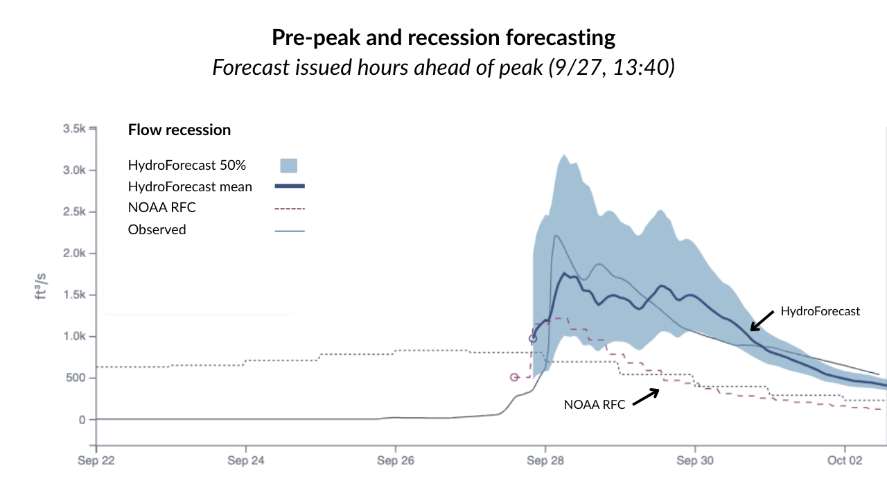
In the early morning of the 28th, the flows, water levels, and flooding peaked. The Nolichucky Dam was deemed "stable and secure" and water levels began receding. Emergency hotlines were established and recovery crews were deployed to assess the extensive damage.
HydroForecast accurately reflected the receding limb of the flood. Predicted recession timing and magnitude even before the peak occurred. RFC showed recession but with uncertainty about the exact rate and timing due to loss of real-time data from gauges.
While peak flow is often the first priority ahead of flooding events, the recession—how long elevated water levels persist—is critical data for emergency managers. The level and duration of high water can impact how and when emergency crews are deployed, as well as determine when it becomes safe for residents and civilians to enter an area. After Helene, water receded slowly over several days. Some rivers in Western North Carolina stayed at flood levels through the first week of October 2024.
Even before the peak occurred, our analysis showed HydroForecast accurately predicted recession timing and magnitude. With early insight into elevated water levels, teams can make more informed decisions around resource allocation and deployment while providing clear, consistent guidance to communities.
Hurricane Helene tested water managers across the Southeast in unprecedented ways. The storm showcased both the ingenuity of teams on the ground and the critical cracks that can occur in traditional forecasting methodologies when pushed to the limit. While catastrophic dam failure was ultimately avoided, the event made clear that we can—and must—integrate more resilient and performant technologies. As climate change continues to intensify hurricanes, and inland flooding risks are projected to increase, the road to resiliency is a rapid implementation of advanced forecasting technology to protect the communities living in the path of the next unprecedented storm.
If you want to learn more about the results of this case study, please reach out to our team for additional technical details.
.png)
.png)
.png)