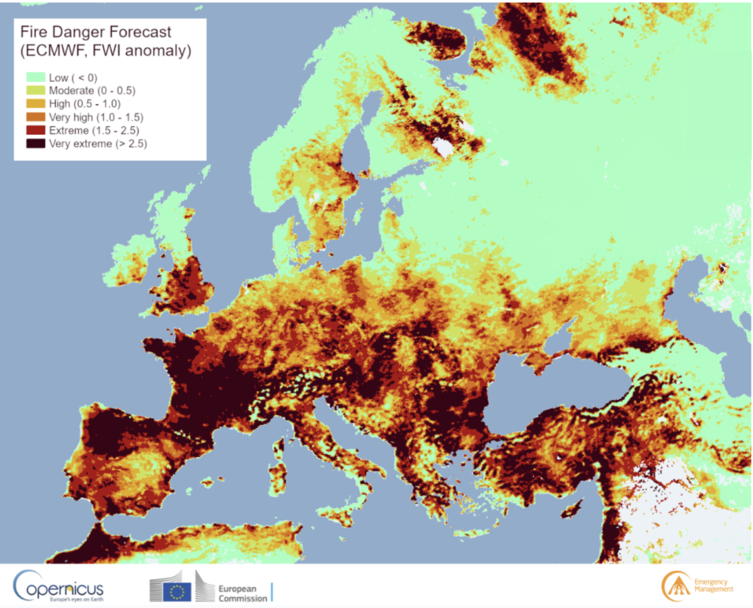
Late summer in the Northern Hemisphere is fire season. At the time of writing, wildfires are actively burning across the western United States, Canada, and parts of Europe. Some of their impacts are felt immediately: hazardous air quality, evacuation orders, and burn bans. Other repercussions occur slowly and subtly, affecting ecosystems and watersheds long after the fires are extinguished. Water flowing through burn scars sends sediment downstream to accumulate against dams, damages water infrastructure, and alters the timing and volume of runoff.
Accurately predicting the sudden hydrological shifts after fires is essential for safeguarding communities, preserving critical infrastructure, and ensuring sustainable water resource management in fire-affected regions.
Wildfires reshape how water moves across a landscape—reducing infiltration, accelerating erosion, and most visibly, stripping away vegetation. Vegetation plays a critical role in watershed hydrology, intercepting rainfall, slowing its impact on the ground, anchoring soil, and shading snowpack to regulate melt rates.
The loss of vegetation triggers cascading effects throughout the watershed. Precipitation and snowmelt reach streams faster, often in larger, more erratic pulses. In snow-fed basins, melt may start earlier and finish more quickly, altering both the timing and volume of downstream flows. These changes can happen virtually overnight, transforming a watershed's runoff patterns to resemble those of an entirely different climate zone. Prior assumptions about vegetation cover, infiltration rates, and snowmelt timing suddenly become obsolete, rendering existing hydrological models inadequate.
This vegetation loss represents one of the most immediate and consequential changes to watershed hydrology, yet it's remarkably difficult to capture in real time. Traditional monitoring stations may be damaged or destroyed, burn severity varies widely across each fire's footprint, and conditions continue evolving as vegetation begins its slow recovery. In this shifting landscape, wildfires introduce a powerful, unpredictable variable into an already complex hydrological system, making accurate streamflow forecasting far more challenging.
One of the most effective ways to monitor vegetation health and density is through the Normalized Difference Vegetation Index (NDVI). NDVI uses satellite measurements of visible and near-infrared light to quantify photosynthetic activity—how "green" an area is. This is a strong indicator of vegetation cover.
Real-time integration of NDVI is critical for adaptable streamflow forecasting. Traditional hydrologic models, however, often lack the capability to incorporate NDVI in real time. They often instead rely on state vegetation parameters or infrequently updated land cover datasets, meaning that post-fire landscape is represented as if it were still intact. Vegetation parameters in these models can be adjusted to account for vegetation loss, but they cannot adapt automatically in real time.
HydroForecast is built with a unique AI infrastructure that allows it to integrate updated vegetation data into its forecasts on a daily basis using NASA VIIRS satellite data. This high-frequency input means forecasts can adjust to the altered hydrologic response of a watershed almost immediately, rather than operating with outdated data from pre-fire conditions. By feeding current vegetation status into the model, HydroForecast can better capture the evolving dynamics of post-fire runoff and maintain forecast accuracy as the landscape recovers.
>> Learn more about how HydroForecast works.
Upstream Tech specializes in hydrologic forecasting and geospatial data analysis. Our expertise extends beyond HydroForecast to include Lens, our remote land monitoring platform, giving our team extensive experience in satellite data processing and analysis.
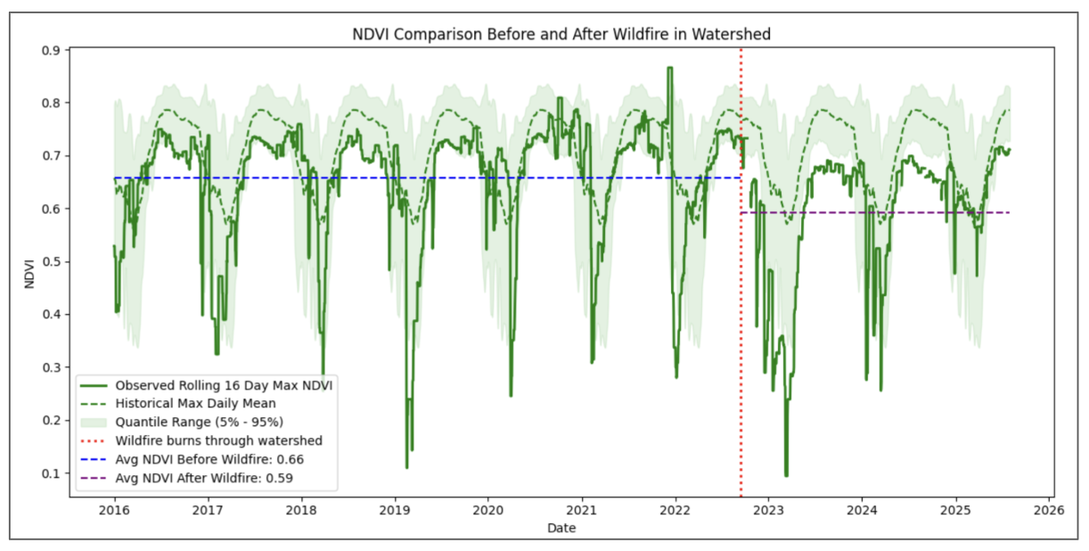
Healthy, dense vegetation reflects more near-infrared light and absorbs more visible light, producing higher NDVI values. Areas stripped bare by wildfire show sharp drops in NDVI, revealing the extent and severity of vegetation loss.
The below image illustrates the NDVI within a sub-basin of a HydroForecast customer in California before and after a wildfire. The NDVI shifts downward after the wildfire passes through the sub-basin, indicating fire induced vegetation loss. Because HydroForecast integrates updated NDVI values on a daily basis, the model can account for these changes in landscape in real time.
It is not only the inclusion of NDVI, but also the model training process itself, that makes HydroForecast especially well suited to adapt to watersheds which have been shaped by wildfire. Because the base model is trained on over 500+ watersheds, the model understands how catchments react to abrupt changes in NDVI. The Long-Short Term Memory (LSTM) network retains that information as vegetation starts to recover, just as it retains snowpack accumulation data throughout the winter. When NDVI satellite data sources were added to the HydroForecast base model for training, the model showed clear improved performance across basins.
While wildfires are part of natural ecosystem cycles, climate change is driving hotter and drier conditions that are leading to more intense and frequent fires. But the impact on our water systems can be reduced if we adapt the way we manage water in fire-affected basins. HydroForecast is designed with this adaptability at its core. By integrating NDVI and daily satellite surface observations, the model continuously tracks changes to the landscape and incorporates them into forecasts, ensuring that shifts in vegetation and runoff patterns are captured as they happen.
Looking ahead, the ability to integrate dynamic Earth observation data into forecasting models is not just valuable for fire recovery—it’s essential for a future defined by rapid environmental change. By leveraging tools that learn and adapt in real time, we can build water management systems that are more resilient, more accurate, and better prepared for the uncertainties of a changing climate.
Are you managing water in fire-affected areas? We'd love to hear from you. Reach out to the HydroForecast team to learn more about adaptive streamflow forecasting.
.png)
.png)