.png)
Most discussions on streamflow forecasting focus on gauged locations — how well a model tracks observed flows; how it handles extremes; how far ahead it produces useful forecasts. But for a large portion of the world’s river network, there are no gauges, and there isn’t one likely to be installed anytime soon.
Monitoring infrastructure is expensive, geographically biased toward large accessible rivers, and vulnerable to failure precisely when that data is most critical. Advances in machine learning have changed what’s possible in these settings: models trained across hundreds of diverse basins can now generate reliable operational streamflow forecasts at ungauged locations, without any local calibration data. HydroForecast applies these methods operationally, providing modeled inflow forecasts at ungauged locations that would otherwise require years of gauge installation and calibration, all at a fraction of the cost and time.
This blog post explores the scope of the monitoring gap, the research behind this approach, and what it makes possible in practice. For a higher-level overview of how HydroForecast applies these capabilities, see our ungauged forecasting executive summary.
Installing and maintaining a telemetered stream gauge is a sustained cost commitment ($25K–$40K to install, $16.5K–$32K annually to maintain per site). A 2022 study in Nature Sustainability analyzed over 32,000 gauges globally and found they cluster disproportionately in large, perennial rivers draining heavily populated watersheds—a pattern driven by cost, funding gaps, and accessibility. Protected areas, non-perennial streams, remote headwaters, and smaller tributaries are systematically under-monitored.

The pattern holds globally. There are well-documented gaps across northern Canada. In Europe, researchers estimate flow-duration curves for ~24,000 river basins by interpolating from just 3,000 discharge stations—meaning most of the continent’s river network has no direct monitoring. In New Zealand, regional councils rely on gauge networks to issue flood alerts, but those networks are vulnerable to vandalism and theft, and cannot realistically extend to every reach that needs monitoring. While Auckland Council uses HydroForecast to support subject matter experts making real-time emergency decisions and coordinating cross-departmental flood response, other regional councils have not yet integrated more advanced forecasting tools to support ungauged locations.

These gaps have real consequences for regulatory compliance, environmental flow assessment, infrastructure planning, and disaster response. Physical networks are also fragile: a single 2018 telemetry error took 11% of the USGS national network offline for weeks.
Traditional hydrological models are calibrated basin-by-basin using local gauge records. Without those records, predictions degrade. This approach simply doesn’t scale. HydroForecast takes a different path. Our model is built on Long Short-Term Memory (LSTM) neural networks trained simultaneously across hundreds of basins spanning diverse climates and hydrologic regimes.
A key 2019 paper in Water Resources Research co-authored by our CTO, Alden Keefe Sampson showed that an LSTM approach, with no local calibration data, could outperform individually calibrated conceptual models at ungauged locations.

Deployed to a new location, HydroForecast uses physical basin characteristics and meteorological inputs to generate real-time operational forecasts—without relying on any local gauge record. This has practical implications:

HydroForecast delivers continuous flow estimates that can be used to understand current and historic streamflow conditions, and probabilistic multi-day forecasts that ingest meteorological forecasts and daily satellite data. This allows the model to track landscape changes like post-fire recovery, seasonal dynamics, and land use shifts as they occur.
Together, these capabilities mean that the spatial coverage of a basin’s flow information is no longer constrained by where monitoring infrastructure happens to exist. Inflow forecasting becomes possible for ungauged tributary catchments across many use cases, including:
For regulators and resource agencies working across large, heterogeneous regions, HydroForecast adds valuable coverage — consistent, updatable flow information at every reach that matters.
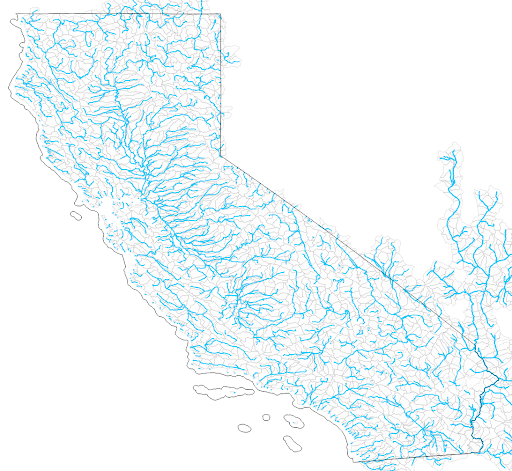
In California, we partnered with The Nature Conservancy and the Wildlife Conservation Board on a custom statewide modeling project that generated 20 years of daily streamflow data, both actual and natural (unimpaired) conditions, at every river reach across the state. This included thousands of ungauged sites where systematic flow records had never existed. It's a practical demonstration of what becomes possible when physical monitoring constraints are removed from the spatial extent of hydrological analysis.
>>> A comprehensive technical report and a public release of the dataset are forthcoming. Subscribe to our newsletter to be notified when they are available.
Physical monitoring networks are valuable and irreplaceable for model validation, high-precision regulatory measurement, and the accumulation of long observation records. It is, in large part, because of these networks that large-scale ML is possible at all. But they are also expensive, geographically biased, subject to funding discontinuities, and vulnerable to physical failure at the exact moments when data is needed most.
Modeled streamflow generated by physics-informed AI doesn’t have those same vulnerabilities. It provides spatially continuous coverage across an entire basin, with a fundamentally different setup process and cost structure for each additional forecast point.
The goal isn’t to replace physical monitoring. It’s to build a complete, resilient picture of watershed hydrology that physical infrastructure alone cannot provide—and to make flow information available wherever decisions are being made, not just where gauges happen to be installed.
Data gaps don’t have to be decision gaps. Want to explore what ungauged forecasting could unlock in your region? Connect with our team.